 geocat.ch
Tiefe Bohrungen
Forages profonds
Perforazioni profonde
Deep wells
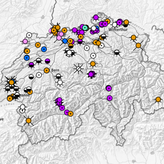
Diese Karte zeigt die tiefen Bohrungen in der Schweiz an. Die Daten stammen vom Bundesamt für Landestopografie swisstopo, von Universitäten, Kantonen und privaten Unternehmen. Die Metadaten sind öffentlich zugänglich. Die damit verbundenen Dokumente, wenn sie öffentlich sind, sind über den Kartenviewer des Geoportal des Bundes (map.geo.admin.ch) zugänglich. Für Auskünfte über die Dokumentation wenden Sie sich bitte direkt an den Rechteinhaber. Die Karte wird regelmässig überarbeitet und stellt keinen Anspruch auf Vollständigkeit. MD = Measured depth, TVD = True vertical depth, TD = Total depth
Cette carte montre les forages profonds situés en Suisse. Les données proviennent de l'Office fédéral de topographie swisstopo, d'universités, de cantons et d'entreprises privées. Les métadonnées sont accessibles au public et les documents associés, lorsqu'ils sont libres pour la publication, sont disponibles via le Géoportail de la Confédération (map.geo.admin.ch). Pour tout renseignement concernant la documentation, prière de contacter directement les propriétaires des droits respectifs. La carte est régulièrement mise à jour et ne prétend pas être exhaustive. MD = Measured depth, TVD = True vertical depth, TD = Total depth
Questa carta mostra le perforazioni profonde in Svizzera. I dati provengono dall'Ufficio federale di topografia swisstopo, come pure da università, cantoni e aziende private. I metadati sono pubblicamente accessibili. I documenti ad essi associati, se pubblici, possono essere scaricati tramite il Geoportale della Confederazione (map.geo.admin.ch). Per qualsiasi informazione in merito alla documentazione si prega di rivolgersi direttamente ai titolari dei rispettivi diritti. La carta viene aggiornata regolarmente e non pretende di essere completa. MD = Measured depth, TVD = True vertical depth, TD = Total depth
This map shows the deep wells in Switzerland. The data come from the Federal Office of Topography swisstopo, from universities, cantons and private companies. Metadata are publicly accessible and the associated documents, when they are free for publication, are accessible through the Federal Geoportal (map.geo.admin.ch). For any information concerning the documentation, please contact the rights holder directly. The map is revised regularly and does not purport to be complete. MD = Measured depth, TVD = True vertical depth, TD = Total depth
Simple
-
Autre titreAltri nomi o acronimiAlternate titleAlternate titleAlternativtitel
-
Tiefe Bohrungen
Forages profonds
Perforazioni profonde
Deep wells
-
Date (Création)Data (Creazione)Date (Creation)Date (Creation)Datum (Erstellung)
- 2017-07-11T00:00:00
-
Date (Révision)Data (Revisione)Date (Revision)Date (Revision)Datum (Aktualisierung)
- 2026-04-14
-
IdentifiantIdentificatoreIdentifierIdentifierKennung
- ch.swisstopo.geologie-bohrungen_tiefer_500
-
ÉtatStatoStatusStatusBearbeitungsstatus
-
ContinuIn corsoOn goingOn goingKontinuierliche Aktualisierung
Propriétaire
Proprietario
Owner
Owner
Eigentümer
-
Type de représentation spatialeTipo di rappresentazione spazialeSpatial representation typeSpatial representation typeRäumliche Darstellungsart
-
vecteurVettorialeVectorVectorVektor
-
Catégorie de thèmeCategoria ISOTopic categoryTopic categoryThematik
-
-
F Informations géoscientifiquesF Informazioni geoscientificheF Geoscientific informationF Geoscientific informationF Erdwissenschaften
-
Étendue
Estensione
Extent
Extent
Ausdehnung
Étendue
Estensione
Extent
Extent
Ausdehnung
-
DescriptionDescrizioneDescriptionDescriptionBeschreibung
-
Switzerland (extent of the railway network with areas close to the border)
Schweiz (mit grenznahem Ausland)
Suisse (extension du réseau ferré avec l'étranger près de la frontière)
Svizzera (estensione della rete ferroviaria con parziale copertura oltre frontiera)
Switzerland (extent of the railway network with areas close to the border)
-
Identifiant géographiqueIdentificatore geograficoGeographic identifierGeographic identifierGeografische Kennung
- CHCHCHCHCH
))

-
Fréquence de mise à jourFrequenza di aggiornamentoMaintenance and update frequencyMaintenance and update frequencyWartungsintervall
-
TrimestrielleTrimestraleQuarterlyQuarterlyVierteljährlich
- GEMET
-
-
ressource renouvelable
risorse rinnovabili
renewable resource
-
géologie
geologia
geology
-
énergie géothermique
energia geotermica
geothermal energy
-
forage
perforazione
drilling
-
ressource énergétique
risorse energetiche
energy resource
-
- geocat.ch
-
-
géothermie
geotermia
geothermal energy
-
opendata.swiss
opendata.swiss
opendata.swiss
opendata.swiss
-
IFDG l’Infrastructure Fédérale de données géographiques
IFDG Infrastruttura federale dei dati geografici
FSDI Federal Spatial Data Infrastructure
-
confédération
confederazione
confederation
-
Contraintes sur la ressource
Vincoli sulle risorse
Resource constraints
Resource constraints
Ressourcenbeschränkungen
-
Contraintes d'utilisationVincoli d'usoUse constraintsUse constraintsNutzungseinschränkungen
-
Autres restrictionsAltre restrizioniOther restrictionsOther restrictionsAndere Beschränkungen
-
Autres contraintesAltri vincoliOther constraintsOther constraintsAndere Einschränkungen
- Opendata BY: Freie Nutzung. Quellenangabe ist Pflicht.Opendata BY: Utilisation libre. Obligation d’indiquer la source.Opendata BY: Libero utilizzo. Indicazione della fonte obbligatoria.Opendata BY: Open use. Must provide the source.
Ressource associée
Risorsa associata
Associated resource
Associated resource
Verlinkte Ressource
-
Type d'associationTipo di associazioneAssociation TypeAssociation TypeAssoziationstyp
-
Citation de travail plus largeCitazione di un'opera più ampiaReference to a master resource of which this one is a partReference to a master resource of which this one is a partÜbergeordneter Datenbestand
-
Metadata ReferenceRiferimento metadatiMetadata ReferenceMetadata ReferenceMetadatenreferenz
-
LangueLinguaLanguageLanguageSprache
- Deutsch
-
Encodage de caractèresCodifica dei caratteriCharacter encodingCharacter encodingZeichenkodierung
-
Utf8UTF8UTF8UTF8Utf8
-
Catégorie de sous-thèmeCategoria di sottotemaSubtopic CategorySubtopic CategoryThematische Unterkategorien
-
F1 GéologieF1 GeologiaF1 GeologyF1 GeologyF1 Geologie
-
Catégorie de sous-thèmeCategoria di sottotemaSubtopic CategorySubtopic CategoryThematische Unterkategorien
-
Q1 ÉnergieQ1 EnergiaQ1 EnergyQ1 EnergyQ1 Energie
Options de transfert numérique
Opzioni di trasferimento digitale
Digital transfer options
Digital transfer options
Optionen für die digitale Übertragung
-
Ressource en ligneRisorsa onlineOnLine resourceOnLine resourceOnline
-
Vorschau map.geo.admin.ch
Vorschau map.geo.admin.chAperçu map.geo.admin.chPrevisione map.geo.admin.chPreview map.geo.admin.ch
-
Format de distributionFormato (codifica)Distribution formatDistribution formatAbgabeformat
-
-
ESRI File Geodatabase FileGDB (GDB)
-
OGC Geopackage (GPKG)
-
Portable Document Format (PDF)
-
Options de transfert numérique
Opzioni di trasferimento digitale
Digital transfer options
Digital transfer options
Optionen für die digitale Übertragung
-
Ressource en ligneRisorsa onlineOnLine resourceOnLine resourceOnline
-
ch.swisstopo.geologie-bohrungen_tiefer_500
WMS-BGDI Dienst, Layer "Bohrungen > 500 m"Service WMS-IFDG, couche "Forages > 500 m"Servizio WMS-IFDG, strato "Perforazioni > 500 m"WMS-FSDI service, layer "Wells > 500 m"WMS-BGDI Dienst, Layer "Bohrungen > 500 m"
Options de transfert numérique
Opzioni di trasferimento digitale
Digital transfer options
Digital transfer options
Optionen für die digitale Übertragung
-
Ressource en ligneRisorsa onlineOnLine resourceOnLine resourceOnline
-
ch.swisstopo.geologie-bohrungen_tiefer_500
WMTS-BGDI Dienst, Layer "Tiefe Bohrungen"Service WMTS-IFDG, couche , Layer "Forages profonds"Servizio WMTS-IFDG, strato "Perforazioni profonde"WMTS-FSDI service, layer "Deep wells"WMTS-BGDI Dienst, Layer "Tiefe Bohrungen"
Options de transfert numérique
Opzioni di trasferimento digitale
Digital transfer options
Digital transfer options
Optionen für die digitale Übertragung
-
Ressource en ligneRisorsa onlineOnLine resourceOnLine resourceOnline
-
Download
Options de transfert numérique
Opzioni di trasferimento digitale
Digital transfer options
Digital transfer options
Optionen für die digitale Übertragung
-
Ressource en ligneRisorsa onlineOnLine resourceOnLine resourceOnline
-
boreholes.swissgeol.ch
Options de transfert numérique
Opzioni di trasferimento digitale
Digital transfer options
Digital transfer options
Optionen für die digitale Übertragung
-
Ressource en ligneRisorsa onlineOnLine resourceOnLine resourceOnline
-
RESTful API von geo.admin.ch
RESTful API von geo.admin.chRESTful API de geo.admin.chRESTful API da geo.admin.chRESTful API from geo.admin.chRESTful API dad geo.admin.ch
-
Ressource en ligneRisorsa onlineOnLine resourceOnLine resourceOnline
-
assets.swissgeol.ch
Identifiant
Identificativo
Identifier
Identifier
Identifikator
-
CodeCodiceCodeCodeCode
- EPSG:2056
-
DescriptionDescrizioneDescriptionDescriptionBeschreibung
-
CH1903+ / LV95 (EPSG:2056)
Metadata
-
Identifiant des métadonnéesIdentificativo della schedaMetadata identifierMetadata identifierIdentifikator des Metadatensatzes
- a61d9f7a-00cd-4448-a36d-b81423f1f566
-
LangueLinguaLanguageLanguageSprache
- Deutsch
-
Encodage de caractèresCodifica dei caratteriCharacter encodingCharacter encodingZeichenkodierung
-
Utf8UTF8UTF8UTF8Utf8
-
LangueLinguaLanguageLanguageSprache
- Français
-
Encodage de caractèresCodifica dei caratteriCharacter encodingCharacter encodingZeichenkodierung
-
Utf8UTF8UTF8UTF8Utf8
-
LangueLinguaLanguageLanguageSprache
- Italiano
-
Encodage de caractèresCodifica dei caratteriCharacter encodingCharacter encodingZeichenkodierung
-
Utf8UTF8UTF8UTF8Utf8
-
LangueLinguaLanguageLanguageSprache
- English
-
Encodage de caractèresCodifica dei caratteriCharacter encodingCharacter encodingZeichenkodierung
-
Utf8UTF8UTF8UTF8Utf8
-
LangueLinguaLanguageLanguageSprache
- Rumantsch
-
Encodage de caractèresCodifica dei caratteriCharacter encodingCharacter encodingZeichenkodierung
-
Utf8UTF8UTF8UTF8Utf8
Propriétaire
Proprietario
Owner
Owner
Eigentümer
Type de ressource
Tipo di risorsa
Type of resource
Type of resource
Anwendungsbereich der Metadaten
-
Domaine d'application de la ressourceAmbito di applicazione della risorsaResource scopeResource scopeDomäne der Ressourcenanwendung
-
Jeu de donnéesSet di datiDatasetDatasetDatenbestand
-
Lien vers la métadonnéeCollegamento ai metadatiMetadata linkageMetadata linkageLink zu den Metadaten
-
Informations de date (Création)Informazioni sulla data (Creazione)Date info (Creation)Date info (Creation)Datumsangaben (Erstellung)
- 2017-07-14T07:24:22Z
-
Informations de date (Révision)Informazioni sulla data (Revisione)Date info (Revision)Date info (Revision)Datumsangaben (Aktualisierung)
- 2026-07-02T08:33:27.80537Z
Norme des métadonnées
Standard dei metadati
Metadata standard
Metadata standard
Metadatenstandard
-
TitreTitoloTitleTitleTitel
-
eCH-0271