 geocat.ch
Carte piscicole - rivières
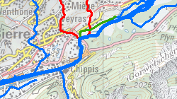
Linéaire piscicole principal du canton selon le type de cours d'eau (Rhône de plaine, Rhône de montagne, rivière de plaine, rivière de montagne, réserve de pêche et rivière affermée).
Simple
- Alternate title
-
Carte piscicole - rivières
- Date (Creation)
- 2013-11-06
- Date (Revision)
- 2026-02-17
- Identifier
- 175
- Purpose
-
informer le public sur les rivières et canaux ouverts à la pêche
- Status
- Completed
Custodian
- Spatial representation type
- Vector
Spatial resolution
Equivalent scale
- Denominator
- 25000
- Topic category
-
- T Economy
Extent
Extent
- Description
-
Canton of Valais (VS)
))

- Maintenance and update frequency
- userDefined
- Maintenance note
-
tous les 5 ans
Resource format
- Title
-
ESRI Enterprise Geodatabase
- Date
- GEMET themes
-
-
fishery
-
- GEMET
-
-
fish
-
fish farming
-
wild animal
-
- geocat.ch
-
-
opendata.swiss
-
Resource constraints
- Use limitation
-
Aucunes
Resource constraints
- Access constraints
- Other restrictions
- Other constraints
-
Géodonnées accessibles au public (niveau A selon l'OGéo)
- Other constraints
-
Les conditions générales d'utilisation des géodonnées du Canton du Valais font foi ( https://www.vs.ch/fr/web/guest/information-legale).
- Language
- Français
- Character encoding
- UTF8
- Environment description
-
S:\Géodonnées VS\T Activités économiques\Réseau piscicole.lyr
- Title
-
Réseau piscicole (rivières) - Attributs de la table
- Date (Creation)
- 2025-02-17
- Distribution format
-
-
ESRI Shapefile (SHP)
-
autres formats sur demande / andere Formate auf Anfrage
-
ArcGIS REST Feature Service
-
Distributor
Digital transfer options
- OnLine resource
-
Géoportail du Canton du Valais
Géoportail du Canton du Valais
Digital transfer options
- OnLine resource
-
OpenData Valais
OpenData Valais - Site de téléchargement de géodonnées à l'Etat du Valais : multiformat et WebMercator
Digital transfer options
- OnLine resource
-
Landing Page
Landing Page pour opendata
Digital transfer options
- OnLine resource
-
Permalink opendata.swiss
Permalink opendata.swiss
Digital transfer options
- OnLine resource
-
Peche_Reseau
Carte piscicole - rivières
- Statement
-
Digitalisation sur la base du SwissMapRaster
- Hierarchy level
- Dataset
- Description
-
Digitalisation
Equivalent scale
- Denominator
- 25000
- Geometric object type
- Curve
- Geometric object count
- 430
- Reference system identifier
- EPSG:2056/CH1903+_MN95
Metadata
- Metadata identifier
- 2a7bfad3-fa8f-4058-96d8-49643ccaaf25
- Language
- Français
- Character encoding
- UTF8
- Language
- Deutsch
- Character encoding
- UTF8
- Language
- Italiano
- Character encoding
- UTF8
- Language
- English
- Character encoding
- UTF8
- Language
- Rumantsch
- Character encoding
- UTF8
Distributor
Type of resource
- Resource scope
- Dataset
- Metadata linkage
-
https://geocat-int.dev.bgdi.ch/geonetwork/srv/api/records/2a7bfad3-fa8f-4058-96d8-49643ccaaf25
- Date info (Creation)
- 2016-08-22T09:50:41Z
- Date info (Revision)
- 2026-04-13T09:37:51.20309Z
Metadata standard
- Title
-
GM03 2+